Search Term Record
Metadata
Name |
Maps |
Related Records
-
31_1923_1-14 - Meeting Minutes
Meeting Minutes of the Fairhope Single Tax Corporation for the year 1923. (Note pages 13 and 14 contain minutes for the following year, 1924 - the rest of that year can be viewed at 31_1924_1-10.) The 1923 Minutes contain the general business of the Colony; meetings were held twice per month. Some highlights include:objections to enlarging the electric plant because of increased traffic at the bayfront, printing maps of Colony lands,naming of...
Record Type: Archives and Videos
-
33_4_1 - Map
Map of the Fairhope Colony Cemetery dated 1965 and updated June 6, 1988. Shows names and designates if deceased was a veteran. From the Fairhope Single Tax Corporation Archives.
Record Type: Archives and Videos
-
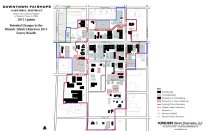
34_69_001 - Map
Map dated 2015 of the Downtown Fairhope Historic District in Fairhope, Alabama as prepared for the National Register of Historic Places. This shows potential changes to the 2006 map (see 34_70_001). From the Fairhope Public Library Collection and the Fairhope Single Tax Corporation Archives.
Record Type: Archives and Videos
-
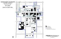
34_70_001 - Map
Downtown Fairhope Historic District Map of Fairhope, Alabama listed in the National Register of Historic Places in 2006. From the Fairhope Public Library Collection and the Fairhope Single Tax Corporation Archives.
Record Type: Archives and Videos
-
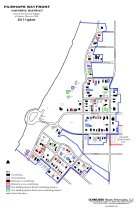
34_74_001 - Map
Map of the Fairhope Bayfront Historic District as listed in the National Register of Historic Places. This 2015 map is an updated to the original1988 map (see 34_75_001). From the Fairhope Public Library Collection and the Fairhope Single Tax Corporation Archives.
Record Type: Archives and Videos
-
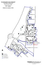
34_75_001 - Map
Map of the Fairhope Bayfront Historic District as listed in the Nation Register of Histori Places. This is the originial 1988 map. The 2015 updated map is at 34_74_001. From the Fairhope Public Library Collection and the Fairhope Single Tax Corporation Archives.
Record Type: Archives and Videos
-
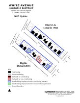
34_78_001 - Map
Map of the White Avenue Historic District in Fairhope, Alabama as listed in the National Register of Historic Places. Original map is 1988 with the 2015 update shown. From the Fairhope Public Library Collection and the Fairhope Single Tax Corporation Archives.
Record Type: Archives and Videos
-
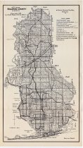
35_10_001 - Map
1958 map of Baldwin County, Alabama by Claude Bagge. Includes section lines in unincorporated areas. From the Fairhope Single Tax Corporation Archives.
Record Type: Archives and Videos
-
35_15_001 - Map
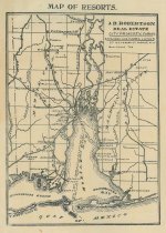
"Map of Resorts" of resort properties on both the eastern and western shores of Mobile Bay, and north to Citronelle. Published by J. B. Robertson Real Estate in Mobile, Alabama. No date. From the Fairhope Single Tax Corporation Archives.
Record Type: Archives and Videos
-
35_4_001_002 - Map
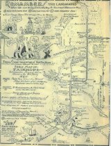
Map by William A. Dealy (Will Dealy) of Fairhope, Alabama between 1898 and 1905. Dealy titled the map "Dem Were Da Daze," presenting Fairhope citizens in a humorous light, while providing interesting information about local goings-on in Fairhope as well as the locations of homes, businesses and even moonshine stills. Two scans are included, each one with attributes depending on the user's needs. From the Fairhope Single Tax Corporation A...
Record Type: Archives and Videos
-
35_8_001_028 - Brochures
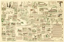
"Highlights and Highways of Baldwin: The 1939 Guide to Baldwin County Alabama." Includes articles, advertisements, maps, as well as illustrations by Walter Overton. Published by The Goldenrod Studio in Magnolia Springs, Alabama. This promotional brochure cost twenty-five cents and provided information on "what to see and how to get there" in Baldwin County, "America's newest playground on Mobile Bay and the Gulf of Mexico." From the Fai...
Record Type: Archives and Videos
-
40_39_001-002 - Map
Foldout Map and Directory of Fairhope, Alabama, 23 x 35 inches. 1976. From the Fairhope Single Tax Corporation Archives,
Record Type: Archives and Videos
-
40_47_001-020 - Map
New and Impoved School Atlas, to accompany The Practical System of Modern Gerography. By J. Olney. Damaged by water and pests. From the Fairhope Single Tax Corporation Archives, Fairhope Friends Quaker Collection.
Record Type: Archives and Videos
-
40_51_001 - Map
Map of Fairhope, Alabama titled "The Land of the Jubilees" published by the Fairhope Chamber of Commerce. c. 1950s. Has some hand marking in red ink. From the Fairhope Single Tax Corporation Archives
Record Type: Archives and Videos
-
40_59_001-057 - Documents
LImited print edition of the Fairhope Historic Building Placques Project: a project of the Fairhope Single Tax Corporation Education Committee. 2024. The FSTC Education Committee selected twenty historic structures in downtown Fairhope for the purpose of writing a history of each building and installing an informative plaque of them (with each owner's permission). The plaques have two QR codes: one with the history of the building, and the ot...
Record Type: Archives and Videos
-
4.10.1-115 - Correspondence
Correspondence (Da-Di) of the Fairhope Single Tax Corporation dated 1936-1953 and C. A. Gaston. Included are several letters to C. A. Gaston from Bill Dealy (William Austin Dealy, W. A. Dealy) who was writing from Nashville, TN where he was an engineer with the War Department. Includes some of Dealy's cartoons, drawings and poetry. 4.10.64 is a response to a letter of condolence written to C. A. Gaston on the death of his father, E. B. Ga...
Record Type: Archives and Videos
-
42_03_001 - Map
1961 map of the City of Fairhope, Alabama. From the Fairhope Single Tax Corporation Archives, courtesy of the Ruffles Family.
Record Type: Archives and Videos
-
44_02_01-98 - Land Abstract
Abstract of Title detailing the ownership of land on which the current City of Fairhope is located. Dated 1817-1952. Laurent Millaudon (1786-1868), a New Orleans merchant and real estate developer, acquired the Baron Louis W. De Feriet claim of two tracts on the eastern shore of Mobile Bay to the south of the William A. Patterson tract and north of what was the Weggs Plantation from Arthur Lee Sims in 1837-1838. This area was known as Clifton...
Record Type: Archives and Videos
-
8.8.1-68 - Telephone Directory
1962 Area Directory for Fairhope, Daphne and Spanish Fort. Includes white, yellow and blue pages, emergency contact information, and brief histories of those communities. In addition, an address guide is printed for Fairhope, Daphne, Montrose, Lake Forest, Malbis, Spanish Fort, Belforest, Magnolia Beach, Point Clear, Battles Wharf and Lakewood Estates showing the names and addresses of occupants listed by number and street name. Maps of the are...
Record Type: Archives and Videos
-
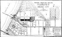
FMH_0070 - Photograph, Digital
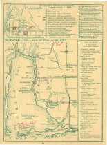
Map of a proposal to develop Fairhope into a planned Organic City, submitted to the Fairhope Single Tax Corporation in 1920 by Signor Cipriano Montoliu. In the November 1, 1920 FSTC Council Meeting, Secretary Gaston was "instructed to communicate to Sr. Montoliu the hearty appreciation of his interest and his carefully worked out plans, the same to be more fully considered at earliest opportunity." Montoliu was a Spainard and a single-taxer ...
Record Type: Photo